Opposition Claims
The proposed mine has sparked confusion, apprehension, and misinformation among the local community. The following sections aim to address these concerns and offer more clarity on the project.
Primary Concerns
Aquifer Opposition Myth
The proposed mine site will negatively impact water levels in surrounding wells and springs, causing them to go dry.
Truth
The proposed mine site will not utilize a groundwater source for process water needs. Therefore, aquifer levels on the subject site and adjacent areas will be unaffected. Mining will stay a minimum of 10-feet above regional groundwater levels, so mining will not alter regional groundwater levels or any adjacent wells in the vicinity.
Water Supply Opposition Myth
The proposed mine will consume all of Cumberland’s water supply and cause the residents to have water shortages.
Truth
The proposed water source for the mine is through Tacoma Water’s large diameter pipelines which are located immediately adjacent to the site. The pipeline carries over 100-million gallons of water south towards Tacoma every day and provides the water source for the Cumberland Co-Op water system. No negative impact to water supply, pressure, or quality would occur to the Cumberland Co-Op water system.
Green River Impact Opposition Myth
The proposed mine will use water from the Green River and cause impacts to the river’s fish species.
Truth
The recent shutdown of the pulp mill on the Tacoma waterfront resulted in the loss of a 36-million gallons a day Tacoma Water customer. This is the equivalent to the water consumption from 100,000 homes. Thus, there is no shortage of supply available from the Tacoma Water pipeline system. Providing the up to 250,000 gallons per day needed by the mine will not create significant impacts on water volume available in the Green River, nor will its withdrawal create negative impacts to fish species.
Deep Creek Impact Opposition Myth
The proposed mine will negatively impact Deep Creek by either drying up the creek or degrading its water quality.
Truth
The Applicant’s hydrogeologist, AESI, established through two years of analysis and testing that Deep Creek is upgradient from groundwater levels under the mine site. Thus, Deep Creek will remain unaffected by any potential changes in water quantity or quality.
Ground Water Opposition Myth
The proposed gravel mine will have severe ground water quality impacts on local aquifers and adjacent wells.
Truth
The proposed mine will meet or exceed State and County stormwater and process water regulations. Stormwater that falls on the mined area will be treated and infiltrated. Process water used in aggregate washing will be captured, stored in a lined pond, treated to remove silt, and recycled through a closed loop process water system. Process water will not be allowed to infiltrate into the ground or runoff to any adjacent waterway. Mining activity that follows stormwater and process water regulations will not impact the aquifer. Segale’s Auburn Pit, which does use groundwater wells for process water for supply, has operated for 50 years immediately adjacent to the City of Auburn well fields and several surrounding parcels private wells, with no impact whatsoever to these aquifers.
Black Diamond Springs Opposition Myth
The proposed gravel mine will contaminate Black Diamond Springs, a water supply source for the City of Black Diamond and also other springs and wells in the area.
Truth
The Applicant’s hydrogeologist, AESI, has verified from multiple previous studies and their own current investigation, that the capture zone for Black Diamond Springs is located significantly south of the proposed mine site. Findings from these studies indicate that the proposed project area does not contribute any groundwater to the Black Diamond Springs capture zone. Further protecting the water quality of all aquifers is the requirement to mine at least 10-feet above regional groundwater elevations, leaving an undisturbed soil profile for precipitation and stormwater to infiltrate through, being further treated, prior to groundwater flow off-site to springs or any adjacent wells.
Import Fill Opposition Myth
Through reclamation the proposed gravel mine must import fill material, much of which will be contaminated, which will leach into groundwater resulting in contaminated groundwater.
Truth
Reclamation of the mine site does not require import of fill material. No importing of fill is proposed. Stripped topsoil and fine material from mining will be combined and used to recontour the site, providing a suitable soil profile for tree growth prior to reforestation.
Green River/Deep Creek Opposition Myth
Runoff from the proposed mine will contaminate the Green River and Deep Creek.
TRUTH
The mine area will be contoured in a bowl shape to avoid runoff into any adjacent areas. The mine site also has a very high infiltration rate, which is the reason no surface water features exist within the mine area, and precipitation infiltrates readily. No runoff from the mine site will reach either the Green River or Deep Creek. Any subsurface flow that reaches the river will have passed through hundreds of feet of vertical and horizontal subsurface soil and rock profile, providing natural groundwater filtration.
Stormwater Opposition Myth
Stormwater cannot be contained and infiltrated on the mine site and will flood adjacent areas.
TRUTH
Stormwater that falls on the actively mined site will be directed to stormwater treatment ponds prior to infiltration. There are no streams within the mine area due to the high infiltration rate of the underlying material. This condition will not change with the mine in operation. The process water storage ponds will be sized to hold peak stormwater events and will not overflow into adjacent areas.
Process Water Opposition Myth
Process water cannot be contained on-site and prevented from infiltrating into the ground or overflowing to the Green River.
TRUTH
All process water activity will occur on impervious surfaces allowing stormwater and process water to be collected on impervious surfaces and directed to oversized lined treatment ponds capable of storing a large volume of water. This water will be pumped, treated to separate fines, and recirculated through the process system daily.
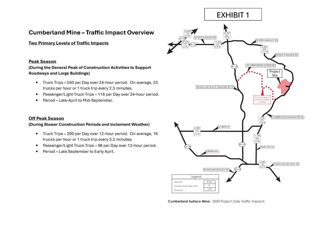
Traffic Impact Overview
Downloadable version available on the “Documents” page.
Traffic Opposition Myth
Projected peak car and truck traffic of 700 trips in a 24-hour period will overwhelm roads and cause gridlock.
Truth
The 24-hour trip generation associated with peak season mine activity is 668 daily car and truck trips, which includes both the inbound and outbound traffic for the facility. This is equivalent to the number of 24-hour daily trips generated by a 67-lot residential subdivision. The haul routes identified for this proposed mine consist of major arterials and state highways to disperse related truck traffic into the region, wherever the construction jobs are occurring. These major arterials and state highways have the capacity to carry the truck traffic from the proposed mine. However, Segale understands that truck trips generate concern. To help mitigate that concern, mine and asphalt plant operators manage their truck traffic to largely avoid PM peak hour traffic. During the off-peak season, during cold and wet weather, traffic impact from the site will drop to approximately 1/3 of the peak season trips.
Regional Traffic Opposition Myth
Traffic generated by the proposed mine site will significantly add to background traffic in the region.
Truth
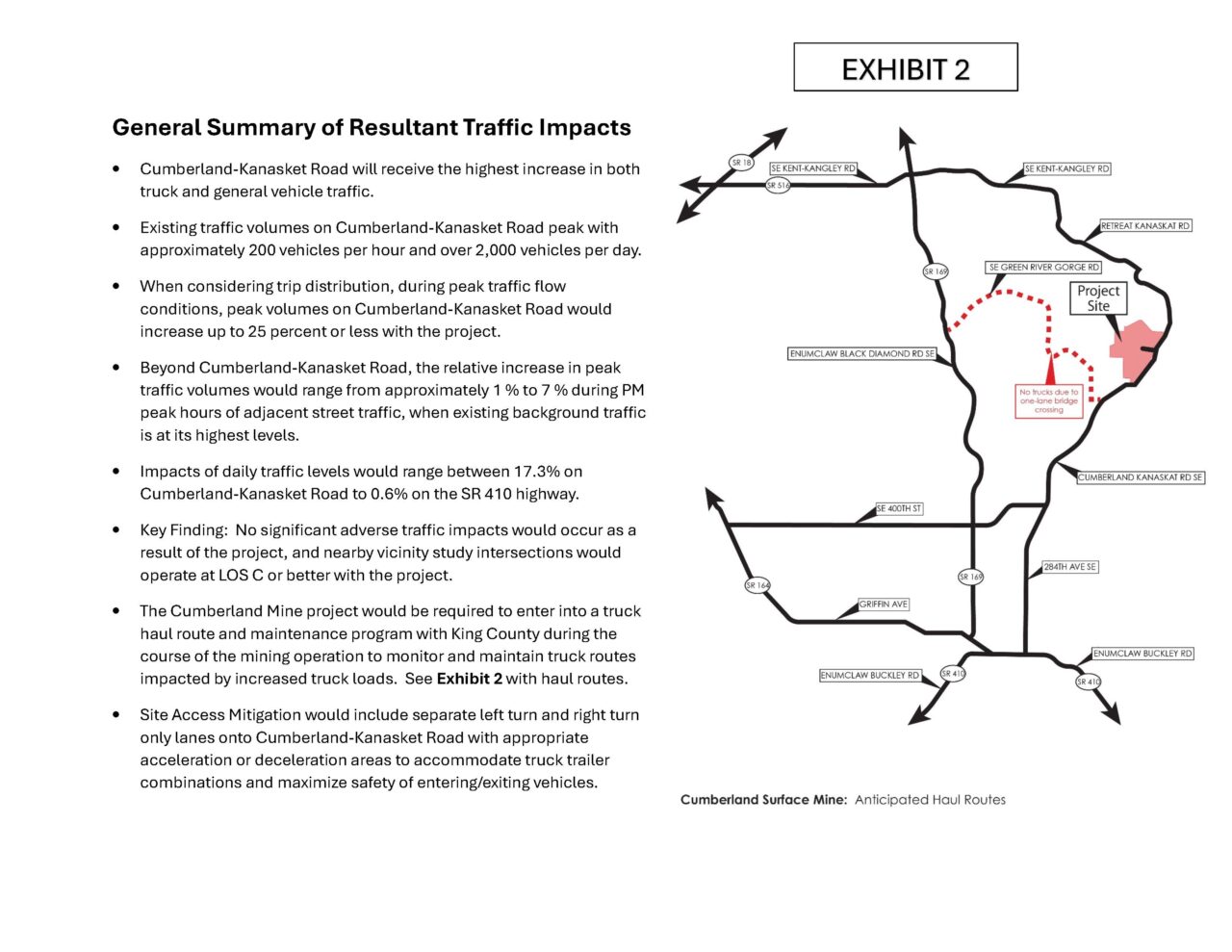
The Applicant’s traffic engineer, TENW, found no level of service impacts from projected mine traffic on haul routes and associated intersections studied. There simply isn’t enough traffic volume generated to create significant impacts to system function. Regardless of whether or not this mine proposal is approved, future construction will create demand for gravel and asphalt and their associated truck trips. Continued growth and development of Enumclaw, Maple Valley, Black Diamond, Covington, and other communities in the region creates the demand for gravel and asphalt products. The only way to eliminate future truck trips associated with movement of these products is to stop development and road building that causes the need for these truck trips. If not from this site, the truck trips will come from other locations to support development as they do now.
Road System Opposition Myth
The existing haul route road system is not capable of handling the heavy trucks associated with the proposed mine.
Truth
The proposed haul routes are on the highest classification roads in the local area and region that have already been carrying logging truck traffic and rock and asphalt truck traffic. The County will provide an assessment of the haul route and associated bridges and note any deficiencies that would need to be addressed as part of the SEPA process.
Traffic Safety Opposition Myth
Trucks from the proposed mine will create a safety hazard to children at bus stops, bicyclists, and planned events in the area such as triathlons, etc.
Truth
Truck drivers for the proposed project will be licensed, professionally trained, and required by contract to follow all applicable traffic laws, including speed limits. Special events such as triathlons, fun runs, races, etc. that are important to the area can be coordinated with the future mine operator to mitigate/manage potential traffic conflicts. Use of flaggers and other special event traffic control methods utilized by law enforcement for significant events can also be used to mitigate safety concerns.
Ingress/Egress Opposition Myth
The proposed mine will create dangerous traffic problems near the mine entrance.
Truth
The Applicant has proposed significant improvements to Cumberland-Kanaskat Road associated with the ingress/egress of the proposed mine, adding deceleration and acceleration lanes, left hand turn lanes with significant vehicle queuing, and exit lanes for truck acceleration as they enter traffic. These improvements will create safe ingress/egress into the site, as well as through lanes, signage etc. to maximize traffic safety.
Fire Danger Opposition Myth
Clearing forest for the proposed mine will increase fire danger significantly.
Truth
The property is designated forestry and is currently in forest use. Existing trees can be harvested/cleared at any time, subject to a harvest permit. Harvesting trees to allow for progressive mine development will not create a significantly different impact to increased fire danger over that of general forest harvesting/clearing. If there is an operational mine on the site, water supply located on-site for processing material, controlling dust, wheel wash, etc., could be accessible to supplement firefighting capabilities.
Wildlife Opposition Myth
The proposed mine will have severe impacts on wildlife and wildlife migrations.
Truth
Raedeke Associates, the Applicant’s biologist/natural resource specialists, prepared a Plants & Animals Assessment Report that indicated the mine proposal did not create a significant impact to area wildlife. Wildlife and gravel operations can and do coexist; Segale’s Auburn Pit is home to a diverse array of wildlife, including deer, elk, bear, and more.
Park Impact Opposition Myth
The proposed mine will negatively impact the adjacent Kanaskat-Palmer State Park.
Truth
The proposed mine abuts portions of Kanaskat-Palmer State Park property. However, areas to be mined and other operations within the mine are hundreds if not thousands of feet away from campgrounds and other activity areas in the park, providing a large setback between these uses. The perimeter of the property will have a minimum 50-foot forested buffer providing additional sight and noise screening for adjacent uses. Noise and air regulations will be met on the perimeter of the entire mine site area, including the shared boundary with Kanaskat-Palmer State Park.
Reclamation Opposition Myth
Reclamation of the gravel pit back to a forest use won’t be successful, trees won’t grow.
Truth
One of the requirements to operate a gravel mine in the State of Washington is to provide a plan for its ultimate reclamation. A Surface Mine Reclamation Permit will be required by the Department of Natural Resources (DNR) prior to start-up of mining activities. DNR will be the responsible approval and reviewing agency for compliance and monitoring associated with the Reclamation plan. Reclamation of mined sites back to forestry uses is common and DNR is uniquely qualified to create, review, and monitor implementation of the Reclamation plan. According to the DNR website for Surface Mining and Reclamation, (https://www.dnr.wa.gov/programs-and-services/geology/energy-mining-and-minerals/surface-mining-and-reclamation#what-is-reclamation) retired mine sites are commonly returned to forestry.
Future Development Opposition Myth
The Applicant is going to build a huge, dense, housing development after mining is completed.
Truth
The proposed mine site is zoned Forestry, meaning residential development is not allowed. Once mining has ceased, the site will be converted back to forest use as part of its ultimate Reclamation.
Lizard Mountain Opposition Myth
The Applicant is going to mine Lizard Mountain and the DNR section their property surrounds, creating a much larger mine than proposed.
Truth
Areas to be mined are clearly identified in the Applicant’s submittal materials to King County. Lizard Mountain is not in the area identified to be mined, nor is the DNR owned Section 16 part of the Applicant’s proposal for mining. As the Applicant does not own the DNR parcel, it could not be part of the mining proposal without DNR’s authorization.
Pollution Opposition Myth
The proposed mine will be noisy, create odors, pollution, etc. that will impact Cumberland residents and adjacent properties.
Truth
Several technical reports were prepared and submitted to the County which address potential impacts due to sound, air pollution/odors, cultural resources, etc. These reports were prepared by qualified scientists in their respective fields. No significant impacts associated with noise, odor, pollution, etc. were identified as likely occurring in any of the expert’s reports.
Purchase Offer Opposition Myth
A purchase offer has been provided to the Applicant by the County and they refuse to sell.
Truth
Washington State Parks has had “plans” for future park area, trails, etc. in this area for decades. These plans have been unfunded to date. Segale has owned this property for approximately 20 years and has never received a formal purchase offer for any part of this site by Washington State Parks or King County. A King County staff person made an inquiry of interest to sell after they learned of the Segale’s intent to submit a mine application to the County.
Road Damage Opposition Myth
The Applicant’s trucks will damage roadways and have already ruined Franklin Road near Cumberland.
Truth
The Applicant does not currently operate a gravel mine in the area and thus has nothing to do with the condition of Franklin Road. Segale will be an advocate with the County to keep the haul route roads in good condition given the large amount of taxes, road-use fees, and other monies that will be paid to the State and County through operation of the mine.
Explosive Use Opposition Myth
Mining operations will include the use of explosives, creating hazards and noise for the community.
TRUTH
No explosive materials will be used on-site during the mining process.